How Three Explorers Serve CUD And Its Ratepayers
A battlefield historian, an anthropologist, and an archaeologist: That’s the unique team that monitors underground utility assets for Consolidated Utility District of Rutherford County (CUD).
“Imagine a ratepayer decides to install fencing or a sprinkler system, but no underground assets have been marked by CUD,” said Matthew Whitten, GIS/GPR Technician for Consolidated Utility District (CUD) of Rutherford County. “While digging holes, the ratepayer hits and breaks a six-inch PVC pipe, or an 18-inch ductile iron pipe. That person would be responsible for time and damages incurred, and the community would be impacted as services are turned off for repair.”
“It’s absolutely critical to know exactly where underground water lines are located.” Whitten has a background in archaeology with the Tennessee State Historic Commission, Middle Tennessee State University, and the Rutherford County Archaeology Society.
“We serve CUD and our ratepayers by keeping all our water line maps current,” said Pam Sykes, GIS Analyst for CUD. “From line locating to helping inspectors out in the field to locating a leak, that all helps us reduce costs and improve water loss prevention.” Sykes holds a degree in anthropology from MTSU and spent more than three years working in the state parks of California.
“As the GIS coordinator, I’m the gatekeeper of the data,” said Bethany Hall. “For our ratepayers, I’m like Google. I research and provide options for solving issues. GIS is becoming one of the core departments at CUD. That’s happening through the creation of dashboards and web applications.”
Before joining CUD, Hall worked for Rutherford County and the City of Murfreesboro in GIS (geospatial information systems) capacities and earned degrees from ITT Tech, American InterContinental University, and MTSU. Though Hall leads the GIS Team at CUD, her previous experiences carried her to distant battlefields overseas.
“I have a fascination with 20th century warfare”
Hall’s journey into GIS began by accident. Her father worked as an electrician and a plumber, and she learned to read blueprints and help him install wiring or plumbing. Through the years, Hall looked for opportunities to use her interests and skills in drafting, geography, and history.
“In 2008, I enrolled at MTSU in the Public History program as a master’s degree student,” Hall said. “I started doing some training on battlefield GIS. I have a fascination with 20th century warfare, and later I did a study abroad in 2009 with MTSU to the islands of Peleliu and Palau.”
A member of Hall’s grandmother’s family fought in World War II with the First Marine Division at the Battle of Palau and was buried near Pearl Harbor. Hall traced his deployments through the war.
“Palau is tiny — only two and a half miles long and about a mile and a half across,” Hall noted. “It’s largely an undisturbed World War II battlefield and still has unexploded ordnance. When I was there, I jumped over a root of a banyan tree, and landed on something metal. I figured my legs were about to be blown off. But what I had landed on were smoke grenades underneath the leaf litter.”
Hall would later work on a project with MTSU that would be titled “The Blue Raiders of Vietnam.” Sixteen men who attended MTSU during Vietnam died while in service there. Researching the efforts of those soldiers led to Hall’s Master of Liberal Arts degree.
The GIS knowledge Hall honed during her education became vital at CUD. “They needed somebody with the GIS background. We’re developing a vision for our information, and we can deploy operational dashboards and data-collecting technology to find our underground lines so our field crews can easily locate them.”
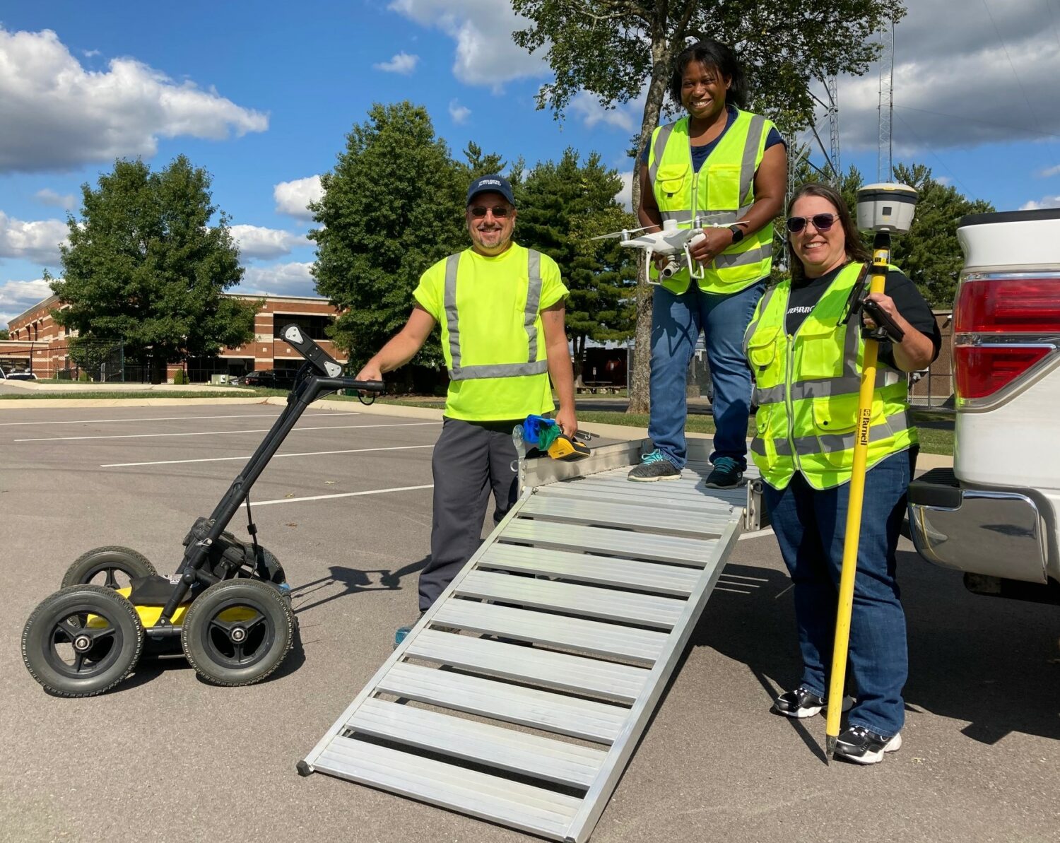
“Plus, I helped bring in a drone program for mapping and preliminary site design. I’ve got 30 hours of manned aviation experience and FAA certification. Using drones allows us to check the physical state of our water storage tanks so we don’t have to send out a crew in safety gear.”
“Because of my background in physics, I like the idea of mapping the universe.”
Visit Pamela Sykes’ workspace, and you’ll see her love of science fiction. Talk to her, though, and you’ll hear about her appreciation of science fact.
“My background originally was in physics due to my love of Star Trek,” said Sykes. “I went through (MTSU) as a physics and biology double major, but I’ve always been interested in anthropology, too.”
“I really enjoy maps because of orienteering and doing outdoor work. Because of my background in physics, I like the idea of mapping the universe.”
After returning to Tennessee, Sykes was approached by a friend about an opportunity with CUD. The role would require GIS capabilities – a skillset she had not used in about five years. Fortunately, the knowledge returned to her quickly, and the technology had improved, too.
“The tech became friendlier, thanks to smartphones,” said Sykes. “Being able to help our guys in the field use the tools and software, it’s all been part of a fun learning curve. As soon as our guys collect data, I’m editing it. Thanks to cell reception, the work moves pretty fast.”
Shooting aerial photography and video using CUD’s drone gives Sykes yet another avenue to use the latest technology. Like Hall, Sykes is an FAA-licensed drone pilot, having earned her certification in 2019. Part of her work involves flying the drone over worksites for pipe installations or structures for STEP systems (Septic Tank Effluent Pump). The data provided by the drone indicates the exact points where infrastructure has been placed – which is vital for inventory control and management.
Sykes has a particular vision in mind for her drone work. “Hopefully, we can start to do some three-dimensional analysis with virtual reality. It would be awesome to see what’s underground without having to dig underground. Especially if something is in the road or close to the road that would cause some problems. The thing is, I love technology, and I’m a gadget person. That’s part of why I’m here.”
“Even from childhood, we’re all explorers.”
Matthew Whitten started as an intern with CUD and learned about GPR (ground penetrating radar) as a method for locating possible submerged walls. That data provides CUD with an idea of where to plot and excavate. The GPR also identifies submerged pipes that were installed throughout the county prior to satellite imagery being taken.
Unearthing the past comes naturally to Whitten since he’s fascinated by archaeology. His collegiate career included work for museums, cemeteries, and an American Indian cultural center. He later gained professional experience developing historical maps and analyzing geographic features.
“I believe that – even from childhood — we’re all explorers,” said Whitten. “That just kind of bled over from history into archaeology, showing places on a map, indicating movement of peoples, mapping out a dig site. That transitioned me into my GIS work.”
Even Whitten’s first connection with CUD related to archaeology. “I met Bethany Hall when I was working a dig in Eagleville in 2014. At the time, I was the vice president of the Rutherford County Archaeological Society. One of the projects was cleaning and restoring the Old City Cemetery, which is now about 200 years old. While working for Rutherford County GIS, Bethany and I went plotting all the cemeteries throughout the county, and we ended up finding new cemeteries.”
Today, Whitten uses his archaeological skills in ways that benefit CUD and its ratepayers. “For a recent example, a contractor wanted to cut a drive into a new subdivision. However, the contractor noticed that a main service line ran across where the new drive was to be located. Our team determined that the blueprints did not agree with a true location. We used our ground-penetrating radar to locate where the line ran, which was roughly six feet off from the blueprints. That way, we helped them avoid a mistake.”
No comments:
Post a Comment